Alberta
Offshore Sailing Association
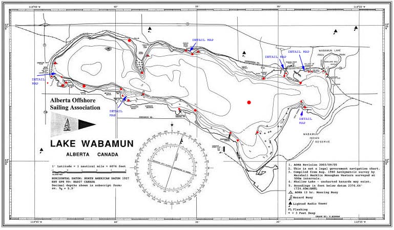
WABAMUN LAKE CHART - Wabamun Lake is located approximately 70 KM due west of Edmonton, Alberta and about 2 KM south of highway 16W, centered around 530 34' 06" North Latitude and 1140 35' 47" West Longitude. The AOSA has long wanted an updated chart for navigating this body of water. We now have one through the collaborated efforts of several members. This was quite an undertaking. Listed below are the features of the chart updated in 2003.
- The print quality is excellent with crisp clean detail. This
should make easier reading for "older" eyes.
- The chart is laminated to make it water proof and compatible with dry markers. Buy some
dry fine point markers at
Staples. They work wonders and are fine enough for the detail required. While you are at it buy a flat Fresnel lens (magnifying) to read the fine detail on the
chart. It is great for anyone who needs a bit of magnification to read a
chart.
- Size is (12 x 18)" which is convenient to use in the cockpit.
- All printing is "north aligned" so you don't have to turn the map over to read the
depth along the north shore
- Compass rose is corrected to 2003.
- The vertical scale is now accurate for
measuring distance at this latitude.
- Map border scale shows DD/MM/SS. These units are much easier to read
and understand to determine your position from the lat/long shown on a GPS
receiver set up for NAD27. Use the map in conjunction with the
AOSA
waypoint table in this web site for really effective navigation
around the lake.
- Depth is shown in decimal feet. Converting them to meters (Canadian
standard) is too
onerous. Wabamun Lake Level
charts. Although it wouldn't hurt to get used to meters.
- Major visual aids to navigation are marked; AOSA cardinal buoys, communication towers,
power plants, roads.
NOTE - Be aware that as of 2014 the only cardinal buoys are Coal Point
and SBYC reed point.
- Be aware that while the AOSA moorings balls are marked on the chart, as of 2011 they are no longer deployed.
As you can see on the sample chart below, there are contour lines, underwater hazards, names of prominent places, communication towers, sail clubs, AOSA cardinal buoys & AOSA mooring balls and a compass rose. Most of the locations are marked with a radio buttons and most have a link to a picture so you can recognize your destination. You can also find the Lat/Long coordinates on the waypoint table to navigate with a GPS receiver. So drag your mouse pointer over the chart and see what you can discover.
AOSA LAKE CHART FOR SALE - A full size laminated (12x18)" chart is for sale through the AOSA. If you wish to purchase a copy please email the web master and I will mail you the instructions. (Very few left).
WABAMUN LAKE
WAYPOINTS
- This table lists the coordinates for the various anchorages, hazards and
destinations on Wabamun Lake so you can use your GPS
receiver to navigate directly to them.
The listing starts at the Wabamun Town dock and goes counter clockwise
around the lake. I chose this direction to match the majority of water traffic. The
table is
located on a separate page
to facilitate printing.
The coordinates are show in decimal degrees. To enter
these coordinates as a waypoint in your GPS
receiver, simply create a new waypoint and edit the coordinates with the values
from this table. This should work for most GPS receivers. Be careful when entering the co-ordinates. One wrong digit
and you may end up on land! With waypoints entered, the strength of a GPS receiver comes into it's own to make
a route or to calculate distance or time. From there it's only a matter of
switching to the correct screen to determine which is the "closest"
hurricane
hole to escape a storm. After all, safety is the primary reason why the AOSA
published this chart. However it is crucial that you set
up your GPS correctly if you wish to use it in conjunction with this Canadian
chart. See
GPS setup.
GPS NETWORK - Want to learn how the GPS network operates? Click here for an excellent system overview from the University of Colorado. The accuracy of the coordinates shown on your receiver GPS network originate from the extremely accurate caesium time base or clock source in each satellite. All satellites are then synchronized to an earth based master time base that is 100 times more accurate than the caesium clock in each satellite. It in turn is synchronized to a star in the Andromeda galaxy. Click here for a view of this master time base that synchronizes all the satellites with Earth bound networks! Just kidding of course.
Magellan
Garmin Trimble
Lowrance
Eagle Apelco/Raymarine/Raytheon
Furuno